
Last modified: 2023-09-09 by ian macdonald
Keywords: chinese regional separatist movements |
Links: FOTW homepage |
search |
disclaimer and copyright |
write us |
mirrors
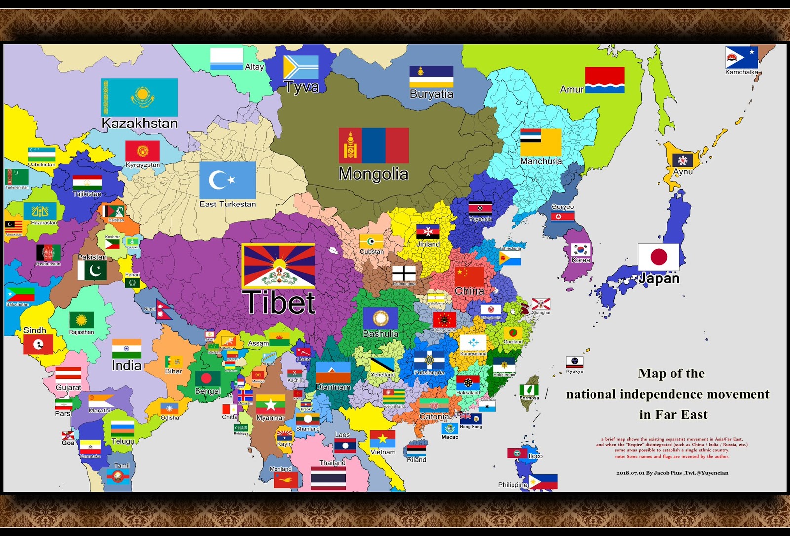
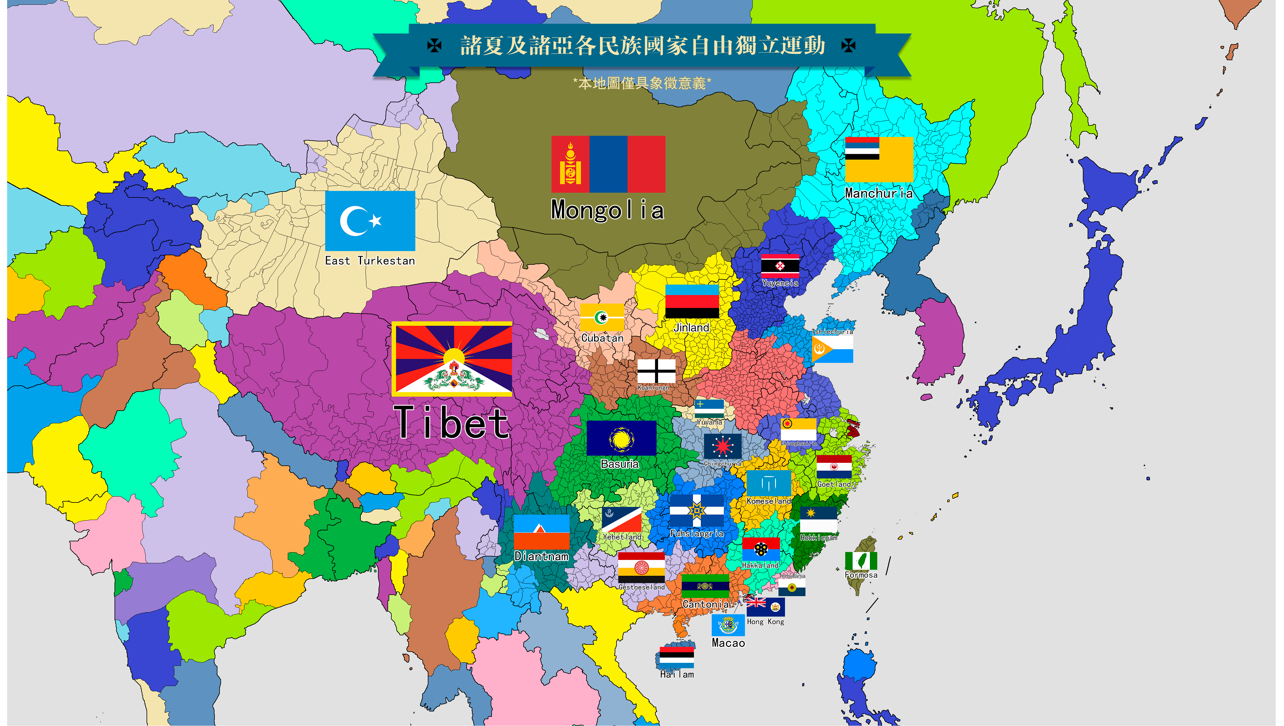
The whole movement of introducing new separatisms of Chinese regions,
including the creation of their flags, seems to have been initiated by a Liu
Zhongjing [1], a Chinese dissident born in Sichuan, currently residing in the
USA. His political theories, while borrowing heavily from the American extreme
right, call for a "de-Sinicization" of Chinese territories with the Han people
making the majority of the population, considering them not a single ethnicity,
but a collection of local identities upon which a single national identity was
imposed by the Chinese Communist Party [1]; the regions with the majority of
ethnic groups other than Han are also considered separate would-be states, as
are Taiwan, Hong Kong and Macau as well. Initially, being a native of Sichuan,
Liu only invented Basuria/Bashulia, his followers adding
other would-be countries and producing numerous maps of a fragmented China, with
the varying number of displayed territories [1, 2, 3, 4, 5]. On some of those
maps, a very rump China is also displayed [1, 2], typically reduced to Henan
province and some adjacent areas (the actual historic core of China), while on
the others, that area is also partitioned between two or more "countries" [3,
4]. Typically, the proposed borders are derived from the current provincial
borders in China, often corrected so as to match the distribution of Sinitic
languages (dialects of Mandarin Chinese usually also being counted as separate
languages), which may mean the addition of completely new entities to a map; the
names of "countries" are derived either from those of the prevailing
languages/dialects or from ancient place names, such as those of the Warring
States which were located in a particular area. Upon each territory on a
particular map, its name in Chinese script, a Westernized name in Latin script
and a flag image are also displayed; the flag designs for a single territory may
vary between the maps, although there are often some clearly prevailing ones,
especially those used in real life. Most of the maps seem to be derived from a
common source [1, 2, 3, 4, 5], although there are also those which differ
greatly [6]; the latter might be created independently from the rest and
sometimes even precede their creation.
Sources:
[1] The China Project
website:
https://thechinaproject.com/2019/03/13/chinas-intellectual-dark-web-and-its-most-active-fanatic
(Map image:
https://thechinaproject.com)
[2] Cathaysian Freedom website:
http://zhuxia.com/web/map_frame_computer.html (Map image:
http://zhuxia.com)
[3] A
map of completely partitioned China at Twitter:
https://twitter.com/fareastyouth
[4] A map of completely partitioned
China at Twitter:
https://twitter.com/arunpudur/
[5] A map of partitioned southern
China at Medium:
https://thelouisluo.medium.com/slay-the-dragon-together-china-as-the-common-enemy-of-india-tibet-and-basuria-bca80241180f
[6] China Matters blog:
http://chinamatters.blogspot.com/2016/06/what-if-it-wasnt-one-china-vs-two.html
All information available on this page is presented for vexillological
purposes only. The political attitudes of the creators and users of described
flags are not related to those of the contributors in any way.
Tomislav
Todorovic, 7 January 2023
![[Flag of Nanjing]](../images/c/cn!hok.gif) image by Brendan, 3 February
2019
image by Brendan, 3 February
2019
A horizontal bicolour, blue over white, with a yellow eight-pointed star in
the top-left corner.
https://twitter.com/hokkienam/status/1082968275871354880
https://twitter.com/hokkienam/status/1076521066502057984
https://twitter.com/biopolymath/status/904182332730564608
Brendan, 3 February
2019
![[Flag of Nanjing]](../images/c/cn!hok2.gif) image by Brendan, 3 February
2019
image by Brendan, 3 February
2019
Another version online shows the star in the centre of the flag.
Brendan, 3 February
2019
Other flags also appear, and the "country" name is also spelled Hookkien.
Tomislav Todorović, 4 February 2019
The "country" is sometimes also named Banvetia, which is a Westernization of
Ban-oat, the Hokkien-language pronunciation:
https://en.wiktionary.org/ of
the name of Minyue:
https://en.wikipedia.org/wiki/Minyue. It is an ancient kingdom which
comprised most of present-day Fujian province.
Tomislav Todorovic,
14 August 2023
![[Flag of Cantonia (Guangdong province)]](../images/c/cn!can.gif) image by Brendan, 3 February
2019
image by Brendan, 3 February
2019
A horizontal tricolour of light green, brown and light blue, with a red kapok
flower outlined in white. This one's been on the Wikimedia Commons since 2014.
https://twitter.com/SKY40065499/status/1080075230456963072
https://twitter.com/CantoniaIP/status/970697119102255104
Brendan, 3 February
2019
This "country" sometimes also includes Guangxi and Hainan, and even Guizhou
and Yunnan. Other flag designs also appear.
Tomislav Todorović, 4 February 2019
![[Flag of Cantonia (Guangdong province)]](../images/c/cn!bash2.gif) image by Brendan, 3 February
2019
image by Brendan, 3 February
2019
An American-looking flag, but with some kind of yellow sun emblem in the blue
field.
https://twitter.com/ChannelNewsAsia/status/1080053561927467008
https://twitter.com/6eLy0Tcw9940h6D/status/1050527458347425792
Brendan, 3 February
2019
![[Flag of Cantonia (Guangdong province)]](../images/c/cn!bash.gif) image by Brendan, 3 February
2019
image by Brendan, 3 February
2019
Also saw a version with just the sun online.
Brendan, 3 February
2019
This name is derived from the names of two Warring States - Ba (https://en.wikipedia.org/wiki/Ba_(state)) which comprised the areas around present-day Chongqing, and Shu - https://en.wikipedia.org/wiki/Shu_(state) which held the areas around present-day Chengdu, the Sichuan province capital. However, variant Basuria sounds as if being invented by speakers of a language which has no l-sound, so it is replaced with r-sound - Japanese being the first to suggest itself, more reasons for it below.
The charges surrounding the sun are the "bird-dragons", an ancient Chinese
decorative motif, also thought to have been a precursor of the Chinese phoenix.
Source: Vilets, Vilijam: Umetnost Kine
Belgrade: Narodna knjiga, 1974
Original title: William Willets: The Foundations of Chinese Art
(c) Penguin
Books Ltd and Thames and Hudson Ltd
[no publishing date of the original work;
finished in 1965, according to the author's introductory note]
Tomislav Todorović, 4 February 2019
The flag with yellow emblem on blue field is prevailing, if not the only one
in real-life use.
Photos
https://www.rfa.org/mandarin/yataibaodao/gangtai/sc-04252022020643.html
https://twitter.com/BasuriaS/status/1444520702162259970
https://commons.wikimedia.org/wiki/
https://nitter.net/i/status/1470474321390968838
The flag design is
derived from the Sun and Immortal Birds Gold Ornament, aka the Golden Sun Bird,
an ancient artifact made of gold - a disc of golden foil with five cutouts
shaped like the sun and four birdlike animals; consequently, the latter are
probably not the "bird-dragons" mentioned earlier, although their shape does
suggest them as one of the predecessors of that motif.
Sources:
[1]
Flag explanation at Twitter:
https://twitter.com/basuriafreedom
[2] Golden Sun Bird at Wikipedia:
https://en.wikipedia.org/wiki/Golden_Sun_Bird
This would-be country
comprises only the eastern part of current Sichuan province, its western part,
having been included in the former Xikang province until 1955, being considered
a part of Greater Tibet. Regarding the name, Basuria is the form in
prevailing use, because in the Sichuanese dialect of Mandarin Chinese, the
sh-sound is not used at all, the s-sound being used instead; this fact
further suggests that perhaps the use of letter "r" is actually not a feature
of Japanese or another language lacking the l-sound, but simply a preferred
Westernized form of a Chinese/Sichuanese place name.
Sources:
[1] Xikang at Wikipedia:
https://en.wikipedia.org/wiki/Xikang
[2]
Sichuanese dialect/language at Wikipedia:
https://en.wikipedia.org/wiki/Sichuanese_(language)
[3] Bashu/Basu
nationalism at Wikipedia:
https://en.wikipedia.org/wiki/Bashu_nationalism
Tomislav Todorovic, 14 December 2022
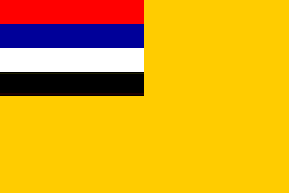
![[Flag of Komland (Jiangxi province)]](../images/c/cn!kom.gif) image by
Tomislav Todorovic, 20 August 2023
image by
Tomislav Todorovic, 20 August 2023
The name Komland is derived from the Gan Chinese word Kom, the counterpart
of the Standard Chinese word Gan, which is the name of the main river in the
Jiangxi province and is also the abbreviated name for the province itself,
being used for the language/dialect spoken in the area as well. Less used
variant Komeseland is derived from the English adjective "Komese", although
the alternate form "Komlish" seems to be used much more now.
The flag
is called "Northern Waters, Three Mountains and Four Swords Flag" [1]. It
displays four white Chinese swords, arranged as the strokes of the Chinese
character 山 ("mountain") placed upside-down, on a light blue field [1, 2, 3,
4]. The horizontal sword stands for the waters (most notably, the Gan river,
which flows northwards) and vertical ones stand for the mountains, while all
of them stand for the courage of the people and their determination to defend
the country [1]. White color stands for piety, while blue stands for the
abundance of the waters [1]. The flag was introduced in 2018 [5]; prior to
that, several other designs were considered which employed the same colors,
but used different symbols [6].
Sources:
[1] Komland Independence Movement blog - Post on 2020-05-24:
https://komlandindependence.blogspot.com/2020/05/blog-post.html
[2]
Twitter - Photos of the flag, posted on 2022-02-27:
https://twitter.com/CuonFuk/status/1498069689657823232
[3] Twitter -
Photos of the flag, posted on 2023-04-16:
https://twitter.com/CuonFuk/status/1647465952894910464
[4] Twitter -
Photo of the flag, posted on 2023-06-05:
https://twitter.com/CuonFuk/status/1665529241541263360
[5] Komland
Independence Movement blog - Post on 2018-10-06:
https://komlandindependence.blogspot.com/2018/10/komland-flag.html
[6]
Komland Independence Movement blog - Post on 2018-05-31:
https://komlandindependence.blogspot.com/2018/05/blog-post_54.html
Tomislav Todorovic, 20 August 2023
![[Flag of Cantonia (Guangdong province)]](../images/c/cn!sha.gif) image by Brendan, 3 February
2019
image by Brendan, 3 February
2019
A red saltire on white with a blue disc in the centre outlined in white.
Clearly based the flag of the Shanghai International Settlement.
https://twitter.com/marsh_yuen/status/1038213482854932480
Brendan, 3 February
2019
This is the first time I found a Shanghainese separatist - or "separatist" -
flag: more frequently, the area is presented as part of a larger would-be
country, comprising all provinces between Shandong and Fujian. That "country" is
called Goetsu, which is Japanese for Wuyue, a 10th-century Chinese state:
https://en.wikipedia.org/wiki/Wuyue
The use of a Japanese word suggests that some of these "separatisms" are
actually the idea of some Japanese or pro-Japanese wishful thinkers. Even more so given the use of the flag of Manchukuo, which was just a
Japanese puppet state. More about the topic can be found here:
http://chinamatters.blogspot.com/2016/06/what-if-it-wasnt-one-china-vs-two.html
Tomislav Todorović, 4 February 2019
As the maps listed above displaying the would-be partitions of China reveal, the present-day definitions of Manchuria vary greatly: at its largest territorial extent, it is identical with the 1934-1945 state of Manchukuo but the areas which nowadays make part of Hebei province are often assigned to other entities, as are some or all the areas which nowadays make part of the autonomous region of Inner Mongolia, thus making its smallest territory consist of the provinces of Heilongjiang, Jilin and Liaoning.
![[Flag of Cantonia (Guangdong province)]](../images/c/cn!man1.gif) image
by Tomislav Todorovic, 21 August 2023,
image
by Tomislav Todorovic, 21 August 2023,
modified from image, created by
Eugene Ipavec
The flags used by the supporters of Manchurian independence also vary. Most
frequently, the flag of Manchukuo is used:
https://twitter.com/freemanchuria/status/1129400045781028865
https://twitter.com/_FreeManchuria/status/1665539375831085056
https://twitter.com/Manchukuo_Gov/status/1294540859518541827
https://twitter.com/Manchukuo_Gov/status/1058694412580995072
https://twitter.com/HantaoZang/status/1650183018454085632
https://twitter.com/mzliubing/status/1665344841289539584
https://twitter.com/mzliubing/status/1649127265244966912
https://twitter.com/CantoniaIP/status/1665637921561493505
https://twitter.com/CantoniaIP/status/1665821690855583746
https://twitter.com/CantoniaIP/status/1665822764513591300
Note that
the shade of blue is usually lighter than it was originally presented for
Manchukuo.
The controversial (to put it mildly) history of Manchukuo and its
flag must have been the factor which has led some activists to introduce a
different design - the blue-white-black horizontal tricolor:
https://www.youtube.com/watch?v=C1GpBWnB_n4
https://twitter.com/PPM_Manchuria/status/1634361871502544897
https://twitter.com/PPM_Manchuria/status/1601789598942003201
https://twitter.com/PPM_Manchuria/status/1601760509787000832
![[Flag of Cantonia (Guangdong province)]](../images/c/cn!man2.gif) image
by Tomislav Todorovic, 21 August 2023
image
by Tomislav Todorovic, 21 August 2023
While it
does look as if "extracted" from the flag of Manchukuo, it is given an
explanation:
https://twitter.com/freenationsrf/status/1660566838340722689 of its own
- sky (blue), snow (white) and soil (black).
There are also the examples of both flags used together:
https://www.youtube.com/watch?v=6NVTTRF-4Qs
Tomislav Todorovic,
21 August 2023