
Last modified: 2012-04-07 by ian macdonald
Keywords: rio grande do sul | derrubadas |
Links: FOTW homepage |
search |
disclaimer and copyright |
write us |
mirrors
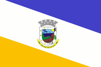 image by Dirk Schönberger, 2
February 2012
image by Dirk Schönberger, 2
February 2012
Source:
http://cid-57cc02038c003794.office.live.com/self.aspx/.Documents
A descending diagonal triband, slightly displaced to an east-west diagonal, blue-white-deep yellow flag with the municipal arms in the centre.
Official website at
http://www.derrubadas-rs.com.br
Dirk Schönberger,
2 February 2012
The municipality of Derrubadas (3,190 inhabitants in 2010; 361 sq. km) is located in northwestern Rio Grande do Sul, on the border with Argentina and Santa Catarina, here river Uruguay, 480 km of Porto Alegre. Near half of the municipal territory (175 sq. km) forms the Turvo State Park.
Derrubadas was originally a small settlement called Porto Garcia, built by Pedro Garcia on the timber concession he owned on the left bank of river Uruguay. In 1937, the newly established Estado Novo regime declared an embargo on Pedro Garcia's company. Ruined, Pedro Garcia abandoned the concession together with his lumberjacks, leaving 6,000 uprooted trees ready to be exported to Argentina and Uruguay. The earlier colonists, stumbling upon the trees, named the place "Derrubadas" (Knock over). The district of Derrubadas was established on 2 February 1955 as part of the "vila" of Tenente Portela, itself part of the municipality of Três Passos. After the emancipation of Tenente Portela on 18 August 1955, Derrubadas was transferred to Tenente Portela by Municipal Law No. 34 of 10 March 1956. The municipality of Derrubadas was established by State Law No. 9,576 of 20 March 1992, following a plebiscite organized on 10 November 1991 by Law No. 9,286 of 9 September 1991, and inaugurated on 3 October 1992.
The coat of arms of Derrubadas is prescribed by Municipal Law no. 27,
adopted in 1993.
The five-towered mural crown symbolizes the political and
administrative independence of the municipality.
The yellow sun represents the emergence of a new horizon, as well as
the resources of the municipality.
The green forests symbolize life, preservation of the environment, the
natural environment and the fields of the municipality.
The blue waterfall is Salto do Yucumã*, symbolizing ecotourism.
The light blue sky represents social harmony and human fraternity.
The ploughed land, clay brown, represents the productive soil and the
agricultural potential of the municipality.
Soybean, maize and wheat represent the main crops forming the base of
the municipal economy.
The plough and tractor represents the means of exploitation of the
soil, manual or mechanized.
The stars represent the five districts forming the municipality: Cedro
Marcado, Barra Grande, Linha Concórdia, Três Marcos and Desimigrados.
The scroll is inscribed with the name of the municipality and its date
of establishment.
Blue and yellow are the colors of the municipality.
http://www.derrubadas-rs.com.br/index.php/brasao
* Salto do Yucumã (Yucumã Waterfall), formed by river Uruguay, marks
the border with Argentina. The waterfall is 1,800 m in width (world
record) and 12-15 m in height. The channel in which the water falls is
30 m in width and 90-120 m in depth.
http://www.derrubadas-rs.com.br/index.php/yucuma - with photos and
videos.
Ivan Sache, 20 March 2012