
Last modified: 2020-07-18 by ian macdonald
Keywords: rio grande do sul | entre rios do sul |
Links: FOTW homepage |
search |
disclaimer and copyright |
write us |
mirrors
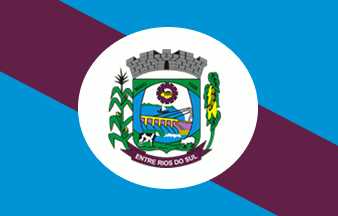 image by Dirk Schönberger,
9
February 2012
image by Dirk Schönberger,
9
February 2012
Source:
http://portal.cnm.org.br/sites/8000/8063/bandeira_site.jpg
The municipality of Entre Rios do Sul (3,O52 inhabitants in 2016; 12,044 ha)
is located 400 km north of Porto Alegre.
Entre Rios do Sul emerged around
the hydro-electric power plant established on river Passo Fundo. The new town of
Vila Alegre was settled in 1959 by the Dall'Agnol, Brustolin, Correia and Silva
families. Vila Alegre was elevated to the 4th district of Săo Valentim by Decree
No. 67 issued on 4 October 1963. The construction of the barrage started in
1966, attracting several workers and civil servants to the town.
The
municipality of Entre Rios do Sul, named for its location between two rivers
("entre dos rios"), here Passo Fundo and Erechim, was established by State Law
No. 8,614 promulgated on 9 May 1988.
https://www.entreriosdosul.rs.gov.br/
Municipal website
Ivan Sache, 17 July 2020
The flag of Entre Rios do Sul was adopted in 1989 in a
student's contest, as "A rectangular flag with three diagonal stripes, purple in
the center to represent the soil of Entre Rios do Sul, surrounded by blue
representing rivers Passo Fundo and Erechim that waters the municipality.
The
coat of arms of Entre Rios de Sul, designed by another student, highlight the
municipality's resources.
https://www.entreriosdosul.rs.gov.br/Munic%C3%ADpio
Ivan Sache, 17 July 2020