
Last modified: 2021-12-11 by ian macdonald
Keywords: santa catarina | zortéa |
Links: FOTW homepage |
search |
disclaimer and copyright |
write us |
mirrors
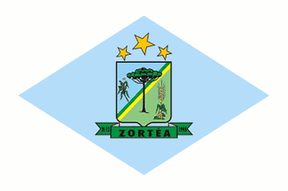 image by Dirk Sch—nberger,
25 August 2012
image by Dirk Sch—nberger,
25 August 2012
Source:
https://zortea.atende.net/cidadao/pagina/bandeira-2
The municipality of ZortÕa (2,991 inhabitants in 2010; 19,015 ha) is located,
on the border with Rio Grande do Sul, 430 km west of Florianµpolis.
ZortÕa is
Brazil's last municipality on the alphabetic list.
ZortÕa was established
in the 1910s, during the building of the railway connecting SÐo Paulo to Rio
Grande do Sul. At the time, the area mostly belonged to Cipriano Rodrigues de
Almeida and Felisberto dos Santos. Around 1930, Alberto Santos acquired plots
from Cipriano and started clearing. This attracted several colonists; in 1946,
the Dambro brothers founded a small sawmill to exploit Brazilian pines, The
sawmill was subsequently acquired by Ant¶nio ZortÕa Primo (the town's namesake;
originating from Valsugana, a region located in the Italian provinces of Trento
and Vicenza) and Guilherme Branche. The development of the hardboard company
ZortÕa e Brancher S/A boosted the emergence of a small town, mostly inhabited by
the factory's workers.
The municipality of ZortÕa was established by State
Law No. 10;051 promulgated on 29 December 1995, separating from Campos Novos.
https://zortea.atende.net/
Municipal website
Ivan Sache, 8 November 2021
A white flag with a large pale blue lozenge bearing the municipal arms in the centre.
Official website at
http://www.zortea.sc.gov.br/home/index.php?
Dirk Sch—nberger,
25 August 2012
The flag of Zortea is prescribed by Municipal Law No. 51 promulgated in 1997.
The municipal flag is white with a celestial blue lozenge.
The coat of arms
represents the municipal government while the celestial blue lozenge represents
the municipality.
Celestial blue represents harmony, people's force, the
indescribably blue sky, horizon and the territory's power.
The white
rectangle is a symbol of peace, friendship, work, prosperity, purity, religious
spirit, honor, civility, courtesy, abundance and hope.
https://zortea.atende.net/cidadao/pagina/bandeira-2
Municipal website
The coat of arms of Zortea is composed of Samnite shield surmounted by three
yellow stars, the central star representing the municipal seat and the other the
communities forming the municipality.
In the upper left part, a maize plant
represents one of the municipality's main crops. In the center, a Brazilian pine
represents the main source of income and the majesty of native trees. In the
right part, soybean and wheat represent the main crops. The shield is divided
from the lower left to the upper right angle by a green and yellow stripe
representing the Motherland.
On the scroll, the toponym "ZortÕa" surrounded
by "29/12" and "1995", respectively, in letters argent on a leaf green
background, indicating the date of foundation of the municipality.
https://zortea.atende.net/cidadao/pagina/brasao
Municipal website
Photos
https://www.facebook.com/PrefeituraZortea/photos/4420114128047191
https://www.facebook.com/PrefeituraZortea/photos/4352968701428401
Ivan Sache, 8 November 2021