 image located by Masao Okazaki, 3 October 2025
Source: https://www.facebook.com/photo.php

Last modified: 2025-11-08 by rob raeside
Keywords: prince edward island | cornwall | half maple leaf | buildings | trans-canada highway |
Links: FOTW homepage |
search |
disclaimer and copyright |
write us |
mirrors
 image located by Masao Okazaki, 3 October 2025
Source:
https://www.facebook.com/photo.php
See also:
About the flag:
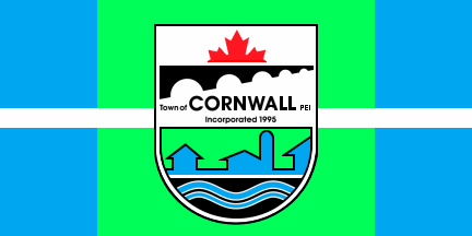
The Town held a Community Flag Designing Contest in July 2006. A lady by the name of Lori Bernard who is a resident of Cornwall won the contest. Her description of the design is as follows:
The two blue rectangles represent the North River and West River with the land (green) in the middle and the town crest to represent Cornwall in the centre. The white strip through the centre represents the (TransCanada) highway that intercepts the Town. The flag became the official for Cornwall in November 2006. - information and image of the flag courtesy by Geneen Bergman from the Town Administration.
Valentin Poposki, 16 September 2009
About the town:
Cornwall (2006 population: 4,677) is a Canadian suburban town located in Queens County, Prince Edward Island. The town is located immediately west of the provincial capital Charlottetown and functions as a bedroom community. The present town was incorporated by the provincial government in 1995 through municipal amalgamation which saw the following unincorporated rural communities merged:
- Cornwall
- North River
- Elliot River
- East Wiltshire
- York Point
The amalgamation did not see any controversies. It was claimed that the name of the community of Cornwall would survive while the others were dissolved." - from Wikipedia :Wikipedia: Cornwall, Prince Edward Island.
Valentin Poposki, 16 September 2009