
Last modified: 2022-03-05 by rob raeside
Keywords: saint-bonaventure | quebec |
Links: FOTW homepage |
search |
disclaimer and copyright |
write us |
mirrors
![[municipal flag]](../images/c/ca-qcxbv.gif) image
by Masao Okazaki, 26 February 2022
image
by Masao Okazaki, 26 February 2022
based on photo located by
Dave Fowler, 23 February 2022
See also:
The municipality of Saint-Bonaventure (1,031 inhabitants in 2016: 8,100 ha)
is located 20 km north-west of Drummondville.
Ivan Sache, 27
February 2022
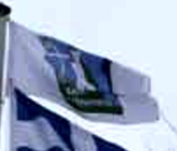
Flag is the municipal arms on white.
Dave Fowler, 23 February 2022
![]() image located by
Dave Fowler, 23 February 2022
image located by
Dave Fowler, 23 February 2022
The logo was selected in a public contest organized from 8 June to 31 July
1987. The contest yielded only three proposals, which were all rewarded with a
prize. On 8 September 1987, the Municipal Council adopted the winning design,
submitted by Claire CŰtť, as the municipal logo.
The irregular contour of
the logo matches the territorial map of Saint-Bonaventure.
The local
topography is featured, showing a flat land and a steep slope heading to river
Saint-FranÁois. The valley's slope is some 30 m in height, except for a lower
section 3 km in length.
Farms of all kinds established in Saint-Bonaventure
are represented by furrows, the grain elevator, and the trees.
The skylight
house highlights the residential character of Saint-Bonaventure.
The upper
left part of the logo represents a window open to the future. The sun represents
the character of Saint-Bonaventure's people.
https://www.saint-bonaventure.ca/description-du-logo
Municipality
website
Ivan Sache, 27 February 2022