
Last modified: 2023-06-03 by  zachary harden
Keywords: heves | felsotarkany |
Links: FOTW homepage |
search |
disclaimer and copyright |
write us |
mirrors
 (2:3)
(2:3)
by Zoltán Turay, 10 December 2004
See also:
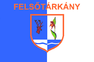
The colours, blue and white, are equal with fresh and clean
air, which is obvious here, at the foot of the Bükk Mountains.
Anyway, this combination of colours is also a tradition, as the
local football team has used it since its foundation, 1952.
Three flags of different size with the Coat of Arms and name of
the village are used. The inscription is gold.
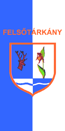
1. Flying flag (Vertical Flag) - The ratio:
2:1 (200x100 cm) - It can be seen in front of the mayor's office.
It is a flag with equal blue and white vertical stripes (1:1) and
the Coat of Arms of Felsotárkány is in the centre of it .
2. Staffed flag - The ratio: 2:3 (40x60 cm) - It is a staffed
flag with equal blue and white vertical stripes (1:1) with the
Coat of Arms and name of the village. It can be used by the
members of the local government, hoisting it at their own houses.
3. Small table flag of Felsotárkány. The ratio: 5:3 (25x15 cm)
It is similar to the big flying flag, but with gold tassels.
Zoltán Turay, 10 December 2004
 (2:1)
(2:1)
by Zoltán Turay, 10 December 2004
hv-fe.gif)
by Zoltán Turay, 10 December 2004
Commission to draw up the plans for the Shield of
Felsotárkány was given by the local government in 1992 to
Trojan Marian József, graphic artist from Füzesabony and to
local art teacher, Kiss Lászlóné. Both persons made many
plans, from which one of the schemes of Mr Trojan was accepted.
Order on method of creating and using of the shield and flag of
Felsotárkány was adopted by the local government on 1 April,
1993. Description of the Shield: It is divided into four parts
and framed with gold. On the left, there is brown head of stag
symbolizing hunting and game-breeding on a blue basis. On the
right, a special and rare wild flower can be seen, called Boldogasszony
papucsa (Lady's slipper/Cypripedium) with white background.
In Hungary, this kind of orchid can be found here, solely. The
bottom of the shield is also divided into two, white and blue
parts with opposite-coloured waves. It represents Brook Tárkány
and Brook Imóko, flowing through the village symbolically.
Zoltán Turay, 10 December 2004
Information on the village is from Felsotárkány homepage
and local publications, written in Hungarian and English. It is
known that 'Tárkány', the basic name of the village means
'(black)smith' but the origin of its name is still unclear. While
one says, it is Hungarian, other claims it is Hunnish-Avar.
"Felsotárkány lies in the picturesque Tárkány Basin, at
the foot of the Bükk Mountains, 12 kilometres from Eger, along
the north-eastern border of Heves County. The settlement was
first mentioned in a written document in 1261 as Oltarkan and
Feltarkan, but on the basis of the archeological finds and
ethnographical researches, we can say it had already been an
inhabited area for a long time, when the Hungarians came here at
the end of the 9th century. In the 14th and 15th centuries the
settlement consisted of two independent villages, Alsótárkány
(Lower-Tárkány) and Felsotárkány (Upper-Tárkány). Between
1330 and 1335, Carthusian monks moved into the monastery built in
a valley, near Felsotárkány. After 1526 the Turks destroyed
Medieval Felsotárkány, which was never inhabited again. In
1552, Alsótárkány was also completely destroyed by the Turks,
together with the Carthusian monastery. However, this part of the
settlement was repopulated after 1577. Between 1634 and the
mid-20th century, the village was in the possession of the
Church. In 1634, the village was inhabited by serfs, and it was
around this time that its name - Felsotárkány - became final.
Around 1750, Bishop Barkóczy rebuilt the Fuorcontrast Palace and
the monastery, given to Nazarenian monks at that time. (.) By the
beginning of the 20th century both buildings had come to nothing,
although names of fields - Kastélykert/Palace Garden,
Barát-rét/Monks' Meadow - are still marking their old sites.
(...) The Tárkány Basin is situated between Várhegy and
Orhegy, at 180 to 340 metres above sea level. (...) The village
is embraced by the Bükk Plateau from the south. The outskirts of
Felsotárkány are 90% covered with forests. A major sectoin of
the area of the village is part of the Bükk National Park, which
is extraordinarily rich in plants and plant combinations. (...)
The settlement is a typical village situated on the banks of a
brook: with a cluster of houses in the western part and a row of
cellars running from the centre to the north. The population of
Felsotárkány has been increasing recently, a phenomenon due to
the natural enviroment and the closeness of Eger. (...) The
Felsotárkány Forest Railway going through the forest is of
special interest for visitors. The outstanding and traditional
events held in Felsotárkány are regularly attended by
delegations from sister-settlements, Köröstárkány (Romania),
Nagytárkány (Slovakia), Dickenschied (Germany) and other
Tárkánys from Hungary, Mezotárkány (Heves County), Tárkány
(Komárom-Esztergom County). The May Day celebrations, the
Felsotárkány Pilgrimage as well as the events of Saint Stephen
Festival, organised around the lake and often attended by
thousands of people every year, have become integral parts of the
social and cultural calendar of the region." Number of its
inhabitants in September, 2004: 3,405.
Zoltán Turay, 10 December 2004