
Last modified: 2026-05-30 by ian macdonald
Keywords: diego garcia | limuria | chagos islands | diego garcia | tree | chagos | palm | british indian ocean territory | crown | limuria | peaks of limuria |
Links: FOTW homepage |
search |
disclaimer and copyright |
write us |
mirrors
![[British Indian Ocean Territory]](../images/i/io.gif) image by Zoltan
Horvath, 16 April 2026
image by Zoltan
Horvath, 16 April 2026ISO Code: IO IOT 086 (Diego Garcia has a reserved code of DG DGA)
Status: territory of the United Kingdom
See also:
Related pages:British dependency, with an important U.S. military base. Is formed by the
Chagos Islands (Diego Garcia, Peros Banhos, etc...)
in the middle of the Indian Ocean.
Jaume Ollé, 9 June 1996
The territory was established on 8 November 1965 by the amalgamation of the
Aldabra, Farquhar and Desroches islands (formerly part of the Seychelles) and
the Chagos Archipelago (formerly from Mauritius. On 29 June 1976 the former
Seychelles islands were retroceded to the Seychelles and were called there 'ZIL
ELOIGNE SESEL'.
Herman De Wael, 24 May 1997
According to the Foreign and Commonwealth Office:
British Indian Ocean Territory (BIOT) lies about 1770 km east of Mahe (the main island of the Seychelles). The territory, an archipelago of 55 islands, covers some 54,400 sq km of ocean. The islands have a land area of only 60 sq km and 698 km of coastline. Diego Garcia, the largest and most southerly island, is 44 sq km. The climate is hot, humid and moderated by trade winds. The terrain is flat and low and most areas do not exceed two metres in elevation.
HISTORY
The Chagos islands were first discovered, uninhabited, in the 16th century.
The French assumed sovereignty in the late 18th century and began to exploit them for copra, originally employing slave labour. By then, the Indian Ocean and its African, Arabian and Indian coasts had become a centre of rivalry between the Dutch, French and British East India companies for dominance over the spice trade and over the routes to India and the Far East. France, which had already colonised Réunion in the middle of the seventeenth century, claimed Mauritius in 1775, having sent its first settlers there in 1772; it subsequently took possession of the Seychelles group and the islands of the Chagos Archipelago. (Although the latter were not commercially important, they had strategic value because of their position astride the trade routes.)
During the Napoleonic wars Britain captured Mauritius and Réunion from the French. Under the treaty of Paris in 1814, Britain restored Réunion to France, and France ceded to Britain Mauritius and its dependencies, which comprised Seychelles and various other islands, including the Chagos Archipelago. All these dependencies continued to be administered from Mauritius until 1903, when the Seychelles group was detached to form a separate Crown Colony. The Chagos islands continued to be administered as a dependency of Mauritius until, with the full agreement of the Mauritius Council of Ministers, they were detached to become part of the British Indian Ocean Territory in 1965. At the same time Britain paid a grant of Ł3 million to Mauritius in consideration of the detachment of the Chagos islands.
After the British Indian Ocean Territory had been created, the UK Government gave Mauritius an undertaking to cede the Chagos islands to Mauritius when they were no longer required for defence purposes. However, since the 1980s, successive Mauritian governments have asserted a sovereignty claim to the islands, arguing that they were detached illegally.
The territory is overseen by a Commissioner and Administrator who are based in London. The Commissioner's Representative in the BIOT is the commanding officer of the British Royal Navy Party at Diego Garcia and who serves as the Justice of the Peace.
In 2001, the population consisted of 1,500 military personnel and 2,000 civilian contractors.
The Royal Navy Party at Diego Garcia numbers approximately 40 people (last
information was 38, down from a maximum of 40).
Phil Nelson, 3 June 2005
The UK will hand over sovereignty of the Chagos Islands to Mauritius – it was
announced on 03 October 2024:
https://news.sky.com/story. But under the agreement, the base on Diego
Garcia will remain under UK and US jurisdiction for at least the next 99 years.
Zoltan Horvath, 7 October 2024
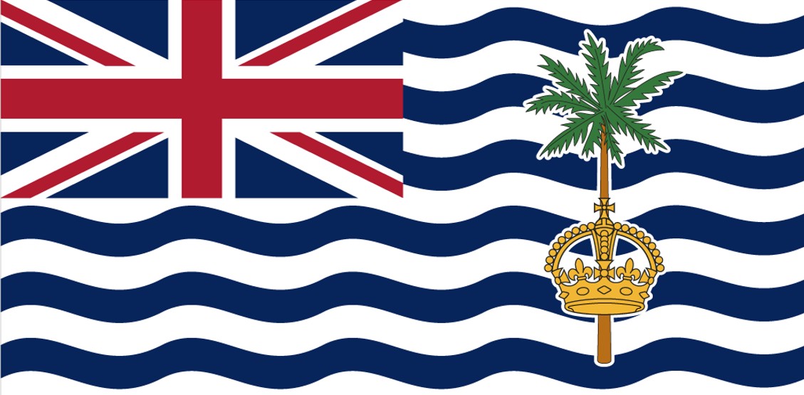
There is a flag, only used by the commissioner. It has wavy lines of blue
and white instead of the blue background of the
Blue Ensign; the
Union Jack in
the canton; and a palm tree with a crown in the fly. Curiously, this flag, as
it appears in my Crampton's Observers Book of Flags [cra90], has the proportions of 2:3 instead of
1:2.
Pascal Vagnat, 1 March 1996
Strictly speaking this is just the flag of the commissioner, the lone
British official who keeps up the pretence that the British Indian Ocean
Territory is anything other than an American base. Because the flag is rather
unlike the usual British colonial pattern, it would not surprise me if it's an
unofficial local creation that has since been ratified (it was formally
adopted in 1990), especially as it's for use on land only.
Roy Stilling, 21 November 1996
For colour specifications, British Indian Ocean Territory uses British
standard colors.
Other sources for colors:
The Olympic Flag Manuals
are not relevant in this issue, while British Indian Ocean Territory is not
member of IOC.
The French Navy Books illustrate the flag, but there is no
color reference. Both the Navy Albums depicts a flag with yellow crown, instead
of a colorful version of the crown. Ratio of flag is 3:5 with a note that it is
can be used in 1:2 ratio.
Vexilla Mundi gives
standard British colors in Pantone system: PMS 281C (blue), PMS 186C (red), and
PMS White.
Wikipedia
illustrates the flag, but doesn’t give any color reference.
Zoltan
Horvath, 23 April 2024
The British Indian Ocean Territory government's website has been updated some
weeks ago, and its flag is changed to a new illustration which used the Tudor
Crown now.
The crown is plain gold, instead of colorful previous version.
Source:
https://www.biot.gov.io/governance/
Zoltan
Horvath, 16 April 2026
![[British Indian Ocean Territory]](../images/i/io0.gif) image by Martin Grieve, 20 August 2006
image by Martin Grieve, 20 August 2006The old crown is the Crown of Saint Edward which was used to represent Queen Elizabeth II. The new one is a monochrome version of the Tudor Crown which was picked by Charles III when he took over in 2022. Presumably it's taken a bit of time to make the switch over on the flag.
https://www.biot.gov.io/governance/
https://robinstanleytaylor.net/2026/04/14/the-tudor-crown-in-the-indian-ocean/
Between 25 February and 22 March 2026 the BIOT government's website changed to a
new illustration which used the Tudor Crown.
https://en.wikipedia.org/wiki/Flag_of_the_British_Indian_Ocean_Territory
Ben Cahoon, 22 April 2026
The metadata relating to the date of the flag image uploaded to the BIOT
government website gives February 26.
https://www.biot.gov.io/wp-content/uploads/BIOT-Flag-Tudor-Crown.jpg
Jean-Marc Merklin, 22 April 2026
.gif) contributed by Zoltan Horvath,
23 April 2024
contributed by Zoltan Horvath,
23 April 2024The arms show a palm tree and St.
Edward's Crown on a base of three white wavy lines representing the ocean, a sun
in splendour in the upper-left corner, and the Union Flag in a chief at the top.
Two sea turtles are used as supporters (a Hawksbill turtle and a Green turtle),
representing the local native wildlife. The crest comprises a naval crown
through which rises a red tower bearing the territory’s flag. The motto is In
tutela nostra Limuria, Latin for “Limuria is in our charge/trust”. This refers
to the non-existent continent of Limuria, once thought to occupy the Indian
Ocean.
Christopher Southworth, 26 September 2024
The coat of arms of [British Indian Ocean Territory] shows the motto of
"IN TUTELA NOSTRA LIMURIA" in some book and another shows the motto
of "PEAKS OF LIMURIA". Which one is correct?
Nozomi Kariyasu, 17 August 2002
"In tutela nostra Limuria" means "Limuria is in our
charge" - Limuria is to the Indian Ocean as Atlantis is to the Atlantic
Ocean - the lost continent. The Peaks of Limuria refer to the same mythical
continent.
Rob Raeside, 20 August 2002
The turtles on the coat of arms undoubtedly were due to the fact that there
is a cove on the island (Turtle Cove) that is home to a large number of sea
turtles.
Kevin Hughes, 11 September 2005